-
FAQ
The Departments of the General Directorate for National Roads and Motorways (GDDKiA) provide the President of UKE with information on service ducts and their routing, using the IT system supporting PIT. For that purpose, they use the UKE Electronic Services Platform to set up accounts for their entities and, via PUE, submit applications for access to the PIT system on behalf of the members of their personnel authorised to transfer the above mentioned information. Once the personnel members receive access data for the PIT system, they can transfer information set out in applicable provisions to that system, using tools made available via the PIT system.
In accordance with the provision of Article 29d(6) of the Act of 7 May 2010 on supporting the development of telecommunications services and networks, the vogt (mayor, town president), starosta and voivodship marshal submit to the President of UKE information on rates for occupying traffic lanes within 14 days from the entry into force of the resolution establishing those rates. In accordance with the provision of §6(3) of the Regulation of the Minister of Digital Affairs of 31 July 2019 on information on physical infrastructure and service ducts and rates for occupying traffic lanes, rates should be entered directly into the PIT system, by means of electronic forms made available in the system, supporting the input of rates, in accordance with the model set out in the aforementioned Regulation.
Access to the full range of information stored in the Information Point on Telecommunications (with the exception of information used for administering the PIT system) can be granted to any telecommunications undertaking which meets the criteria set forth in the definition found in Article 2(27) of the Telecommunications Act of 16 July 2004. Telecommunications undertakings may additionally use the system’s basic analytical tools. Access to information stored in PIT, to the extent corresponding to the scope of information transferred to the system, is provided to entities set out in the provisions of Article 29c, Article 29d(1)–(7) of the Act of 7 May 2010 on supporting the development of telecommunications services and networks.
The system also supports access to several map information layers made publicly available by registers and map portals, both official and social ones, without logging in.
Upon logging in to the map portal, proceed to the control panel. In the “Zarządzanie zasobami” [“Resources management”] section there is an option “Wprowadź dane o planowanej lub istniejącej infrastrukturze” [“Enter data on planned or existing infrastructure”], where information on infrastructure can be uploaded in various data formats (SHP, GML, KML, GPX, GeoTIFF, GeoJSON, DXF, CSV). Moreover, the Information Point on Telecommunications allows for data feeds from a secure network location (e.g. FTP) or by means of configuring a link to an external base. The tool for submitting information offers the option of selecting whether the data concerns existing infrastructure or planned investments as well as choosing the data type: point, linear and surface.
In accordance with Article 25a(1) of the Act of 7 May 2010 on supporting the development of telecommunications services and networks, a network operator shall provide information concerning physical infrastructure to a requesting telecommunications undertaking which intends to implement a high-speed telecommunications network in the area in question. However, if the network operator submits such information to PIT, in accordance with paragraph 5, they can refuse to provide it, to the extent to which it can be accessed via the Information Point on Telecommunications.
Information available in the Information Point on Telecommunications can be browsed on-line (both attribute and geometric data), as well as exported and stored on a personal computer. PIT enables saving data in various formats. Attribute data can be stored in a text file, pdf, docx, xlsx or csv, meanwhile geometric data is exported as gml, dwg, dxf, dgn and shapefile. The option of downloading such data is available after logging in, free of charge and depends on the profile of the entity to which a particular user is attributed.
PIT features a tool allowing to print maps and save them as a file. If a user wishes to do so, they can generate a map compiled according to their preferences, based on layers available in the map portal. With the use of the available tool, the user has such options available as assigning a name or a description to their map, as well as selecting and embedding in the image of the map additional graphic elements which the map is supposed to feature (key, scale, north direction). The user can choose the size and orientation of the printout.
Data is stored in the buffer base for 90 days.
In accordance with Article 6(1)(c) of Regulation (EU) 2016/679 of the European Parliament and of the Council of 27 April 2016 on the protection of natural persons with regard to the processing of personal data and on the free movement of such data, and repealing Directive 95/46/EC (GDPR), personal data processing is lawful, if it is necessary for compliance with a legal obligation to which the controller is subject. In the case of data submitted to PIT by local government units, this obligation arises from Article 29d(4)(2) of the Act on supporting the development of telecommunications services and networks. At the same time, it ought to be emphasised that with regard to the above regulations, the consent of data subjects to submit the data via PIT is not required.
In accordance with Article 6(1)(c) of Regulation (EU) 2016/679 of the European Parliament and of the Council of 27 April 2016 on the protection of natural persons with regard to the processing of personal data and on the free movement of such data, and repealing Directive 95/46/EC (GDPR), data processing is lawful, if it is necessary for compliance with a legal obligation to which the controller is subject. The submission of the aforementioned subject’s data arises from obligations imposed on them by the Act on supporting the development of telecommunications services and networks, and the Regulation of the Minister of Digital Affairs on information on physical infrastructure and service ducts and rates for occupying traffic lanes. Taking into account the above regulations, it ought to be noted that a self-employed entrepreneur must fulfil the obligation imposed on them by submitting all data required by law, even if they constitute personal information.
In accordance with Article 2(1)(6) of the Act on supporting the development of telecommunications services and networks, physical infrastructure includes all elements of an infrastructure or network, which may be used for the purpose of placing in or on them elements of an infrastructure or telecommunications networks without becoming an active element of that telecommunications network, such as pipelines, sewers, masts, ducts, chambers, manholes, cabinets, buildings and entrances to buildings, antenna installations, towers and poles, with the exception of:
a) cables, including optic fibre,
b) network elements used for supplying water intended for human consumption,
c) service ducts within the meaning of Article 4(15a) of the Act on Public Roads.
There is no doubt that information on elements belonging to one of the categories indicated in the above points a–c is not submitted. In other cases, however, the assessment of whether a particular element’s data requires submission under PIT should be left to road operators. In any case, the road operator should assess whether infrastructure elements used for connecting a particular type of media to a property can be used for the purpose of placing in or on them elements of an infrastructure or telecommunications networks. After completing such an assessment, the entity decides whether to submit data or refrain from doing so.
The method of providing data to PIT is specified in the Regulation of the Minister of Digital Affairs on information on physical infrastructure and service ducts and rates for occupying traffic lanes. The Regulation entered into force on 28 November 2019, thus the transfer covers data on physical infrastructure for which the road operator issued a decision on or after 28 November 2019. Information on decisions issued before 28 November 2019 is not to be provided.
For the purpose of information collection by PIT, a single microduct should be treated as other cable sheating.
For the purpose of information collection by PIT, microduct installation in the original duct system should be treated as cable sheating – cable ducting.
For the purpose of information collection by PIT, the multi-hole microduct system should be treated as a prefabricated microduct bundle.
The provision setting out the obligation for road operators to provide data on service ducts entered into force on 1 January 2016. The information on all existing service ducts was to be provided for the first time by 1 October 2016, after that date a deadline of 30 days from the date of completion of the service duct construction applies. It follows from the above that it is the duty of the road operator to provide the President of UKE with information on all service ducts and to update this data within 30 days after a new service ducts is established.
It should be noted that in the case of failure to meet this obligation, the President of UKE is obliged to send a request to the road operator for data to be provided within the specified deadline, and in the case of failure to meet this deadline, to charge the road operator with a fine of PLN 500 for each day of delay.
At the same time, attention should be paid to the fact that the road operator meets the statutory definition of a network operator, therefore they are obliged to provide the data specified in the Act, including data on service ducts, by 31 March, as at 31 December of the previous year.
If a person is registered in PUE as a representative or administrator of several organisations, they may request access to PIT in the context of each of them. Authorisations are granted based on these requests. For example, a user submitted a request for access to PIT in the context of organisation A and a second application for access to PIT in the context of organisation B (organisations A and B have different tax identification numbers (NIP)). For organisation A, the user only has to enter the rates for the right of way occupation, while for organisation B, they must provide information on decisions issued under Article 39 and 40 of the Act on public roads. After logging in to the system, the user selects login (in the upper right corner) and from the drop-down list selects the organisation for which they want to provide data, thus the user has the possibility of switching between accounts.
Pursuant to the Act on supporting the development of telecommunications services and networks, the entity obliged to provide data on the rates for the right of way occupation is the competent commune administrator (mayor, president of the city), starosta or voivodeship marshal.
An LGU may delegate its tasks to other entities. If a road operator is entrusted with the task of providing information on the rates for the right of way occupation, they will be authorised to do so, however, not as a road operator, but as an entity acting on behalf of a given local government unit. If a road operator is entrusted with the task of providing information on the rates for the right of way occupation, an employee of the road operator will be able to do so while working in the context of a given local government unit. To this end, the road operator’s representatives should:
- be assigned as the representative of the local government unit in PUE by the administrator of a given entity (LGU),
- submit a request for access to PIT in the context of the LGU, selecting the role: local government unit.
After authorisations have been granted, the user will be able to work in two contexts: as road operator and local government unit.No, if a given entity does not have the data that are collected in the PIT System, it is not obliged to provide any information in this regard.
A declaration concerning non-possession of infrastructure and non-provision of services that require reporting shall be submitted in the framework of another reporting exercise performed under the Information System on Broadband Infrastructure (SIIS).
In CSV files with point objects, geometry may be recorded in two columns: X and Y (longitude and latitude, respectively). In such a case, when loading data, select the XY option and then indicate the appropriate columns.
In addition, for all types of objects it is also possible to record geometry in one column as the so-called WKT (Well-Known Text). In practice, these are coordinate pairs separated by a comma – depending on the type of geometry, the following record of is used:
- "POINT (21.54 52.47)"
- "LINESTRING (21.54 52.47, 22.23 53.22)"
- "MULTIPOLYGON (((21.54 52.47, 22.23 53.22, 22.55 53.44, 21.54 52.47)))"
It is important that the CSV file contains one geometry type – the system makes it impossible to load files containing points, lines, polygons at the same time. It is also important to remember to use quotation marks.
When uploading the data, the PIT System tries to automatically recognise the coordinate system used in the file. If the attempt is unsuccessful, the user has to select one of the systems applicable in Poland or a geographic coordinate system.
If the user’s data includes coordinates in the form of e.g. 20.23113 (two digits before the decimal point), this indicates the geographic coordinates, thus the WGS84 system should be selected.
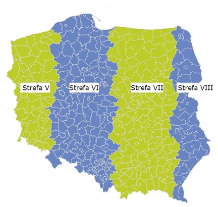
If the data comes from geodetic resources, the most commonly used coordinate system will be one of the four zones of the PL2000 coordinate system. Depending on the poviat to which the data refer, the zone should be selected using the indicative map below.
It is also possible that the data concern a larger area and the coordinate system used is PUWG92.Incorrect selection of the coordinate system will result in displaying the data in the wrong place on the map.
According to the Act on supporting the development of telecommunications services and networks, in this regard, the road operator provides to PIT only the data that they have in electronic format. It should be noted that pursuant to Article 107(1)(8) of the Act – Code of Administrative Procedure, the authority’s decision may also be issued in the form of electronic document.
If the decision was issued in ‘paper form’, the road operator is not obliged to provide data referred to in the decision into PIT.
All owners, perpetual usufructuaries or managers of at least 10 multifamily residential buildings, communal residential buildings or public utility buildings are required to provide information on the address of their websites in the case conditions for providing access to the property and placing on the property facilities and equipment of telecommunications infrastructure are published on these websites. If an LGU belongs to one of the categories listed above, it is obliged to provide data to the extent indicated above.
The attached file contains information on the values resulting from the Ordinance of the Minister of Digital Affairs of 31 July 2019 on information on technical infrastructure and service ducts and rates for occupying traffic lanes to be applied in the PIT System. Value and value code can be used interchangeably.
Basic information on how to prepare the technical infrastructure data is available in the manual for entering CAD data. Detailed information on exporting data from project files prepared in CAD software can be found in the documents of the software uses and on the technical support pages of the software manufacturer.
To check the data provided in the map portal:
- select the active layer,
- open the attribute table,
- create filter (Filter tool) using the name of your organisation (we recommend using the operator ~),
- select data in the attribute table,
- in the attribute table, select Show on map
To get confirmation of data transfer:
- go to the Control panel,
- select the Registers tab,
- open Report store,
- find the report from data feed, for which you want to generate confirmation (Category: Report from data feed) and select Details,
- the report view with information about the feed that can be downloaded to your local drive will open in a new window.
Electronic form refers to vector data (e.g. Shapefile format (4 files in DBF, PRJ, SHP, SHX format required) GML, KML, GPX, XML, TAB, GeoJSON, DXF, DGN, DWG, CSV) with direct spatial reference, in the coordinate system applicable in Poland (excluding local systems), with accuracy of position of at least 1 metre.
At the same time, it should be stressed that raster data (graphic files or graphic designs, e.g. .jpg, .tif, .pdf, .cdr, .psd, .svg) are not uploaded into the PIT System and the entity that has such data is not obliged to convert them.
In view of the above, the entities that have analogue (paper) documents are also not obliged to digitise them.
Type of data
Electronic data on the existing, owned technical infrastructure (which may be used to place elements of telecommunications infrastructure in it or on it) and service ducts
Electronic data on investment plans
financed in whole or in part from public fundsInformation about websites where conditions for access are posted
Information on the rates for the right of way occupation Road operator
x – service ducts
(Article 29d(4) of the Act of 7 May 2010 on supporting the development of telecommunications services and networks)x – service ducts
(Article 29d(4) of the Act of 7 May 2010 on supporting the development of telecommunications services and networks)Commune administrator, mayor, president of the city, starosta, marshal
x (Article 29d(6) of the Act of 7 May 2010 on supporting the development of telecommunications services and networks)
Network manager
x (Article 29c(1) of the Act of 7 May 2010 on supporting the development of telecommunications services and networks)
x (Article 29c(1) of the Act of 7 May 2010 on supporting the development of telecommunications services and networks)
x (Article 18(8) of the Act of 7 May 2010 on supporting the development of telecommunications services and networks)
Restricted area administrator
x (Article 29(3) of the Act of 7 May 2010 on supporting the development of telecommunications services and networks) – data shall be provided at the request of the President of UKE
x (Article 35a(7) of the Act of 7 May 2010 on supporting the development of telecommunications services and networks) Head Office of Geodesy and Cartography (GUGiK)
x (Article 29d(1)–(2) of the Act of 7 May 2010 on supporting the development of telecommunications services and networks)
Other entities x (Article 29d(7) of the Act of 7 May 2010 on supporting the development of telecommunications services and networks) – data shall be provided at the request of the President of UKE Property manager (of at least 10 buildings) x (Article 35a(7) of the Act of 7 May 2010 on supporting the development of telecommunications services and networks) Director of the State Forests’ Regional Directorate X (Article 29b(1)(5) of the Act of 1 May 2010 on supporting the development of telecommunications services and networks,
Article 39b(3) of the Act of 28 September 1991 on forests)After opening the attribute table containing technical infrastructure data in the map portal, the user may access contact information concerning its element. The contact details are defined at the stage of creating account for an entity in PUE (to correctly submit “Wniosek o dostęp do PIT” [“Request for access to PIT”] and to continue work in the PIT System, you need to set up an account for your entity (organisation, company) and assign a representative).
The contact details entered in the above form will then be presented in the attribute table as contact details for the technical infrastructure elements entered by the user.